Shining Rock Wilderness / Middle Prong Wilderness - Newest map in development
Shining Rock Wilderness and Middle Prong Wilderness in Pisgah National Forest
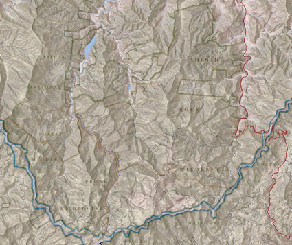
We are incredibly excited to be working on our newest map with the Cradle of Forestry Interpretive Association in America (CFAIA) based out of Pisgah Forest, NC . The idea was originally conceived by the Cradle of Forestry several years back when the USFS map of the Shining Rock Wilderness and Middle Prong Wilderness went out of print. We have considered ourselves proud partners of the Cradle of Forestry for over a decade as they have helped get our maps into the hands of countless users of our great public lands while enhancing their mission to ‘support recreation and education’. With tremendous help and direction from the Cradle of Forestry along with the powerful imagination and cartographic skills of Jack Henderson, this map will be a must for all those interesting in exploring the unique beauty and wildness found in this area. Jack put it best in a recent article on the Transylvania Times website.
“Shining Rock and Middle Prong Wilderness areas embody the rugged spirit and tenacious ambiance of the southern Appalachians. Among these frosted peaks and foggy coves, explorers encounter a wild not often found in an otherwise-developed region of the country.”
Also from the article: “These areas have long been popular destinations for outdoor enthusiasts, and are included within Pisgah Map Company's Pisgah Ranger District map, however this product focuses on the wilderness areas themselves, providing detailed information on the complex network of trails, points of interest, access and landforms.”
Highlighting some of the best mountains of Western North Carolina has to offer. Explore Cold Mountain, Shining Rock, Black Balsam Knob, Sam’s Knob, Tennent Mountain and the high elevation portions of the Art Loeb Trail. Also, find the grassy meadows of Ivestor Gap and cold mountain springs and rivers like Flat Laurel Creek and the Big East Fork of the Pigeon River.